There is some interesting reading about historical Waikawa Beach in the document Te Kotahitanga o Te Iwi o Ngāti Wehi Wehi — Cultural Impact Assessment Ōtaki to North Levin Highway Project 2022. From Pages 8 & 9:
Te Rohe O ngāti Wehi Wehi
Ngāti Wehi Wehi Settlement in the Horowhenua: Waikawa/Manakau
Te Rauparaha established his first Pā in the Horowhenua, at Waikawa, around 1821-1823. This Pā became Ngāti Toa's fighting base against the original tangata whenua of the Horowhenua. Later, Ngāti Kuia and Te Ati Awa were given initial occupation rights to Waikawa, however, in 1826 following escalating inter-iwi disagreements about land allocation, Mokowhiti, of Ngāti Tamatātai/Wehi Wehi was given formal occupancy of Waikawa, being escorted on to the land by Te Rauparaha and other Ngāti Toarangatira chiefs.
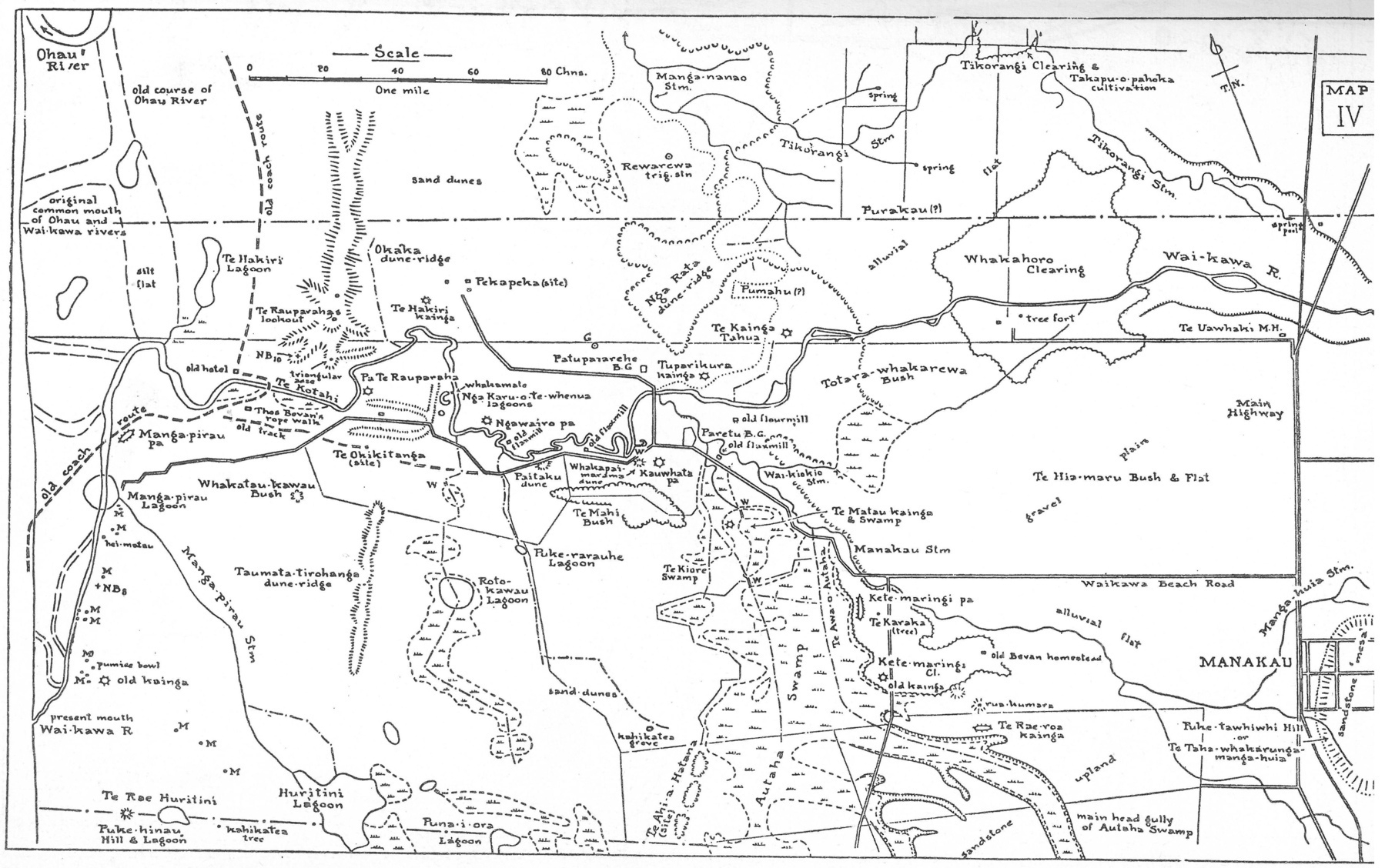
Ngāti Wehi Wehi people first settled near the coastline and along the south side of Waikawa River. There used to be a lagoon at the mouth of the river named,
Manga Pirau, in which the river was shared at that time, by Ngāti Wehi Wehi and Ngāti Tūkorehe hapu, as the Ōhau river and Waikawa river then joined at Manga Pirau lagoon. This lagoon was named Manga Pirau, as was the stream that flowed into it from the Huritini lagoon further south.Manga Pirau means a tributary stream in which the water is contaminated/unpalatable —due to extensive surrounding raupo swamps which provided decaying vegetation. Between the river mouth and the Manga Pirau lagoon the Ngāti Wehi Wehi built their first settlement, which was named Manga Pirau Pā.
Its position beside streams, rivers and sea guaranteed a plentiful supply of food. However, during a massive earthquake in 1885 (sic) the lagoon was completely drained.
Later, a second Ngāti Wehi Wehi settlement called Kauwhata Pā was established at the top of the first hill to the west, along Waikawa beach road. Kauwhata Pā, was named after the father of Wehi Wehi. The Pā comprised a carved Whare Runanga and had three carved Whare Puni:
- Papamapere
- Manawaroa
- Hotumako
Kauwhata Pā eventually became an open kainga that spread out across the present road as far as the Manakau stream. Food was plentiful with the bush providing birds and the river and swamps providing eels. Across the road from the kainga was the Paretu burial ground.
To the west of this burial ground existed the Kai a tekowhitiwhiti flats which abounded in grasshoppers. These made excellent fish bait when threaded to thin strands of flax fibre. A second burial ground belonging to Ngāti Te Rangitawhia, lay across the river at a site called Patupaiarehe, believed to be supernatural spirit beings. Two more Ngāti Te Rangitawhia kainga existed on the northern side of the river. Tuparikura lay a little upstream from the burial ground and Tahua was further upstream again.
Kete Maringi Pā was the third settlement of Ngāti Wehi Wehi people. It was established in a clearing on the south bank of the Manakau stream, slightly west of the present junction of Takapu and Waikawa Beach roads. This was near the stream and the bush line. A track linked the Manga Pirau, Kauwhata and Kete Maringi Pa. Kete Maringi was not a large block of land, and so it was inevitable the hapu would need to relocate to expand.
Kōtare was another populated Pā of Ngāti Wehi Wehi situated at the junction of the Waikawa and Pekapeka roads (1968) where there are two totara trees. (Kōtare is the father of Kauwhata and Tukorehe and grandfather of Wehi Wehi). Another settlement, known as Kotahitanga Pā, contained a fully carved whare Runanga. It belonged to the Ngāti Tamatātai people and was located several hundred metres southwest of the present day Wehi Wehi Pā. The wharenui was used to host local dances for the Manakau community and the school was re-located there while work was being carried out at the Manakau School, but it fell into disrepair after it was blown down in a gale in 1936.
Note: I believe the earthquake date quoted above was a typo — it was probably the huge 1855 quake. See: A terrible state of confusion, in 1855.