On 23 January 1855 at about a quarter past nine in the evening a massive earthquake around magnitude 8.2 on the Richter scale struck the Wellington region. It wrecked many buildings, raised the seabed by about 1.5 metres, and lifted up a huge area of land.

The full force was also felt in the Wairarapa and Manawatu, as this report from Waikawa Beach reveals — The day the earth shifted | New Zealand Geographic says:
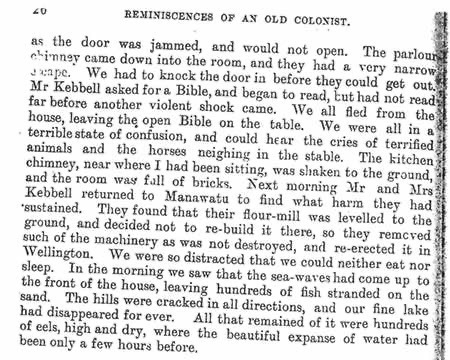
Thomas Bevan, owner of an accommodation house at Waikawa, was seated by a large double-brick chimney with a child on his knee. When the shaking commenced he ran outside but fell on his face, with the child landing some distance ahead. Several guests were similarly thrown off their feet. Everyone was in a “terrible state of confusion,” and they could hear the cries of terrified animals and horses neighing in the stable. …
The most notable and lasting effect of the 1855 Wairarapa earthquake was the sudden uplift and tilting of the south western part of the North Island, and corresponding subsidence of the coastal area of the Wairau Valley across Cook Strait in Marlborough.
I wanted to check whether the Waikawa
mentioned above was ‘ours’ in Horowhenua, and can confirm it is. Check the Preface to Deb Shepherd’s book, Bitter Water. She also mentions a work called Reminiscences Of An Old Colonist (11 MB PDF) by Thomas Bevan Senior. Pages 25 and 26 of that document carry an interesting account of the earthquake, including a tsunami and loss of a lake.
Page 24 of Bevan’s account says that at that time the Ohau River and Waikawa River mouths converged, making a large river suitable for trading boats and creating a picturesque lake full of fish, ducks and other game. That is the lake that is now no more.
First published as A terrible state of confusion, in 1855 : [lovewaikawabeach.micro.blog/2017/06/1...](http://lovewaikawabeach.micro.blog/2017/06/11/a-terrible-state.html) That blog is now defunct.